

Runway Heading Meaning: Complete Guide for Skydivers
What is Runway Heading?
Runway heading is the magnetic compass direction a runway points, rounded to the nearest 10 degrees and displayed as a two-digit number. For example, Runway 27 points west (270°), while Runway 09 points east (90°). Every runway has two numbers—one for each direction—that always differ by exactly 18 (representing 180 degrees).
Understanding runway headings is a fundamental skill for any skydiver. These numbers painted on the runway aren't just airport markings—they're your instant navigation tool for determining wind direction, planning landing patterns, and orienting yourself at any dropzone in the world. Master this simple concept and you'll immediately elevate your situational awareness on every jump.
📋 Note: As of the 2025 USPA Skydiver's Information Manual (SIM) revision, runway heading interpretation is no longer a required topic for A-License certification. However, we believe this fundamental navigation skill remains essential for situational awareness, wind assessment, and safe operations at any dropzone—which is why we continue to teach it.
How to Read Runway Headings
At any airport with paved runways, you'll notice large numbers painted at each end. These numbers correspond directly to the magnetic compass heading of that runway.
Identifying Runways vs. Taxiways: One easy way to distinguish runways from taxiways is that runways are the only paved surfaces with numbers and heading markings. Taxiways use letters (A, B, C, etc.) and yellow centerlines, while runways have white markings and the distinctive two-digit numbers.
Compass Basics Refresher
- North: 0° or 360°
- East: 90°
- South: 180°
- West: 270°
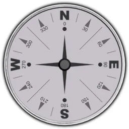
Cardinal directions on a magnetic compass. Runway headings use these same degrees.
The Two-Digit System
Runways are named for their magnetic compass heading, rounded to the nearest 10 degrees. Only two digits are used (01 to 36), following International Civil Aviation Organization (ICAO) rules.
Example: A runway heading 260° magnetic = Runway 26
Why Runways Have Two Numbers
Every runway can be used in two directions, so each end has its own designation. These two numbers will always differ by exactly 18 (representing 180 degrees—the opposite direction).
Example:
- One end heading 40° = Runway 04
- Opposite end heading 220° (40° + 180° = 220°) = Runway 22
- 22 - 04 = 18 ✓
Test Your Knowledge: Runway Headings
Practice converting between runway numbers, compass headings, and directions. Hover over each card to reveal the answer:
What direction?
90° - East
Heading due east
What direction?
180° - South
Heading due south
What direction?
270° - West
Heading due west
What direction?
360° - North
Heading due north
What runway number?
Runway 22
220° → round to 220 → drop last digit = 22
What runway number?
Runway 14
135° → round to 140 → drop last digit = 14
What's the opposite end?
Runway 13
31 - 18 = 13 (or 31 + 18 = 49 - 36 = 13)
What's the opposite end?
Runway 22
04 + 18 = 22
Pro Tip: To find the opposite runway, add or subtract 18. If the result is greater than 36, subtract 36. If it's less than 1, add 36.
Real Example: Reading Your Dropzone
Let's apply this to a real airport. Here's Kay Larkin Field, a typical multi-runway airport used by skydivers:
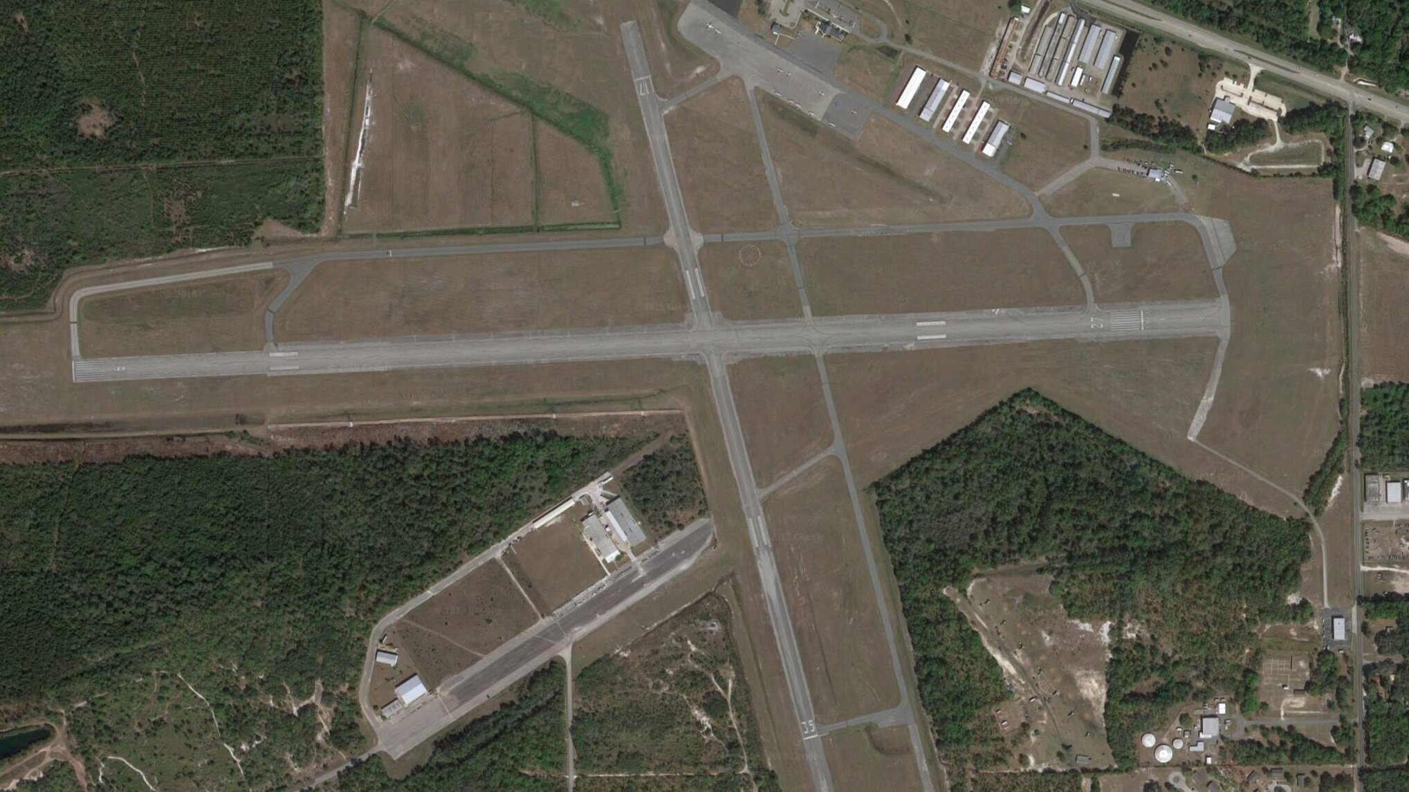
Kay Larkin Field showing multiple runways with different headings.
Step-by-Step Analysis
Runway 09-27 (Center runway, running left-right)
- Left end shows "09" = 90° = East
- Right end shows "27" = 270° = West
- Using Runway 09 means aircraft travel from left to right (heading east)
- Using Runway 27 means aircraft travel from right to left (heading west)
Runway 17-35 (Running top to bottom)
- "17" = 170° = approximately South
- "35" = 350° = approximately North
- Top of the photo = North direction
- Bottom of the photo = South direction
Now You Can Orient Yourself! By looking at ANY runway number at this airport, you instantly know which direction is which. No compass needed. This is exactly how you'll navigate at your dropzone on jump day.
Try It Yourself
Practice Question: If you're standing at the "09" end of the runway and the windsock shows wind coming from your right side, which direction is the wind coming from?
Answer: South! You're facing east (090°), so your right is south (180°).
Clear Communication: Runway Pronunciation
For clear and unambiguous communication, especially on the radio or when discussing ground operations and landing patterns, runway digits are always pronounced individually.
Why This Matters: Individual digit pronunciation prevents miscommunication in noisy environments and maintains consistency with aviation standards worldwide. When you radio "landing Runway Two-Seven," there's zero ambiguity about which runway you mean.
Why Runway Headings Matter to Every Skydiver
Understanding runway headings isn't just pilot trivia—it's an essential navigation and safety skill. Here's how this knowledge directly improves your skydiving:
Instant Ground Orientation
Immediately determine cardinal directions at any dropzone without needing a compass. Essential for understanding and applying wind data.
Accurate Wind Awareness
When you hear "winds from the west," you instantly visualize this relative to the runway and your landing pattern. No guessing.
Optimal Landing Patterns
Knowing the active runway heading helps you understand prevailing winds and plan your most efficient and safest landing approach.
Enhanced Situational Awareness
Interpret your surroundings like a seasoned aviator, adding a powerful layer to your overall skydiving intelligence and safety toolkit.
Professional Communication
Communicate clearly with pilots and other skydivers using proper aviation terminology and runway designations.
Jump Anywhere Confidence
Travel to new dropzones worldwide and orient yourself immediately, no matter the airport layout or local conditions.
Bottom Line: Mastering runway headings is a small but powerful piece of knowledge that significantly enhances your situational awareness and safety as a skydiver. At Skydive Fundamentals, we believe true progression comes from understanding every aspect of your environment.
How to Use Runway Headings on Jump Day
Here's your step-by-step process for applying runway heading knowledge every time you jump:
Identify the Active Runway
Observe which runway aircraft are using (watch the windsock and plane movements) or ask a pilot. Note the runway number (e.g., "Runway 27").
Determine Your Cardinal Directions
Use the runway number to orient yourself. Runway 27 = west (270°), so you immediately know which direction is west, and can figure out all other directions.
Check the Windsock and Winds Aloft
Look at the windsock direction and listen to the winds aloft report. Translate these into compass directions using your runway reference.
Plan Your Landing Pattern
With clear knowledge of wind direction relative to the landing area, plan your approach pattern for the safest, most efficient landing.
Brief Your Jump
Communicate with your group using proper runway terminology ("we'll exit over Runway Two-Seven") for clarity and professionalism.
Real Scenario Example
Situation: You arrive at a new dropzone. You observe aircraft using Runway 18. Winds aloft are reported as "10 knots from 270."
Your Analysis:
- Runway 18 = south (180°), so I know where south is
- Winds from 270° = winds from the west
- I'll plan a landing pattern with a westerly wind component
- I can visualize my entire pattern based on these compass references
Result: Confident, informed jump planning at an unfamiliar dropzone.
Frequently Asked Questions
-
Runway 27 means the runway is oriented at 270 degrees on the magnetic compass, which is due west. Aircraft taking off or landing on Runway 27 are heading westbound.
-
Each end of the runway points in the opposite direction (180 degrees apart). The numbers reflect this—they always differ by exactly 18. For example, if one end is Runway 09 (90°), the opposite end is Runway 27 (270°), and 27 - 9 = 18
-
No need to memorize! Just understand the system: the runway number × 10 = compass heading. Runway 18 = 180° (south). Runway 36 = 360° (north). The pattern is simple once you grasp the concept.
-
Round to the nearest 10 degrees (280°), then drop the last digit to get the runway number: Runway 28. Aviation uses rounding to keep all runway numbers as simple two-digit designations.
-
Yes! The ICAO (International Civil Aviation Organization) standard applies globally. Whether you're jumping in the U.S., Europe, Australia, or anywhere else, runway numbering follows the same magnetic heading system.
-
Observe which runway aircraft are using—watch the windsock and plane movements. You can also ask a pilot. The active runway is typically the one most aligned with current wind conditions to allow aircraft to take off and land into the wind.
-
Absolutely! While the 2025 USPA SIM revision removed runway headings from required exam topics, this knowledge remains invaluable for wind assessment, landing pattern planning, and professional communication with pilots. It's a mark of a truly competent skydiver.
-
Runway headings are magnetic, not true. They're based on magnetic compass headings, which means they point to magnetic north (not true north). This is why runway numbers can occasionally change over decades as the Earth's magnetic field shifts—airports will renumber runways to keep them aligned with current magnetic headings.
Continue Your Skydiving Education
Runway headings are just one piece of the knowledge you need to progress through your USPA licenses. Ready to dive deeper?
At Skydive Fundamentals, we provide comprehensive training and resources to help you become a safer, more confident skydiver. From A-License through advanced instructor ratings, we're here to support your journey.